

This post may contain a few affiliate links, meaning if you make a purchase through them I may earn a small commission at no extra cost to you! As an Amazon Associate I earn from qualifying purchases.
All photos and artwork, as well as written articles on this site, were made by a human being. And always will be :) No ai will ever be used here.
The area around Las Vegas has some beautiful natural desert scenery. If you’re not into gambling, shows, and all that, check some of parks out nearby instead!
Valley of Fire State Park, Nevada’s first state park, is only a 30-60 minute drive away and it was some of the most fun we had on our 2 week road trip out west! It’s a great day trip, or you can even make it a destination to explore for a couple days.
We had just visited Zion National Park the day before, and were driving back towards Las Vegas where we’d get our flight the next day. I spotted Valley of Fire state park on the map and figured it would be a good stop along the way. We arrived around 11:30am, and ended up spending the whole day there until it started getting dark.

We drove along all the park roads, stopping at every major stop and just had fun exploring the desert, climbing up on some of the amazing rock formations, spotting lizards, and we did a couple hiking trails too! There was still several things left that we didn’t get to do though. Valley of Fire is another place I hope to get back to one day-and with it being so close to Las Vegas, it’s easy to rent a car there after getting a flight, so that shouldn’t be a problem 🙂
There is a $10 entrance fee per vehicle upon entering the park.
Best time to go
Valley of Fire is located in the Mojave desert. Needless to say, and if the word “Fire” in the name didn’t catch your attention, it can get very hot there, over 100 degrees Fahrenheit (37+ Celsius), especially in the summer months! When we went it was mid October, and it was still very hot during the day with the sun blazing down on us, but it was tolerable however. I wore a white shirt with long, very lightweight pants, and was fine.
So I highly recommend visiting in the Winter, Spring, or Fall, especially if you want to go do any hiking!

Things to bring with you
- A hat and sunglasses, to keep some of the sun out of your eyes and face. And I mean it is blazing hot and bright! I used one of these shade hats that helped tremendously keeping the sun off my head!
- Sunscreen
- Lots and lots of water!! The dry heat will make your sweat evaporate almost immediately. We were drinking tons of water! Luckily at the visitor’s center there was a water refill station.
- Also bring food with you, as there’s no park services serving food. There are picnic areas at the Visitor’s Center and also at the Seven Sisters pull off.
Camping & Places to Stay
If you want to extend your visit to more than a day, Valley of Fire has it’s own campground and even RV park! Sites are first come first serve, so check in at the visitor’s center or ranger station when you get there.
As far as hotels/motels, the closest place is about a 25 minute drive to the North Shore Inn in Moapa Valley. You could also get lucky and find a place on Airbnb.
Of course Las Vegas is really not a far drive either, so I also recommend staying there if you’re visiting the park-plus there are other parks around Las Vegas such as Lake Mead, and Red Rock Canyon to see as well!
Hiking & Sites to see in the Park
When we drove into the park we came in through the East entrance, knowing that we’d leave through the West, getting a chance to see all of the park road and sites bisecting the park. The road isn’t long however, so even if you enter through the West it’s not a problem to drive all the way up to the East entrance.
Valley of Fire Road – starting from the east entrance
Elephant Rock
Just a little ways past the East Entrance is a small parking lot and pull off for Elephant Rock. It’s a cool red rock formation that, you guessed it, looks like an Elephant! There is a small trail leading up to it, and there are restrooms as well at the parking lot if you need to make a pit stop.
John G. Clark Memorial

As you continue driving along westward, keep your eye out for a white cross on top of a white brick memorial stone on the left hand side. It’s a memorial to the man, John G. Clark, who was traveling through this area back in 1915 with a horse and cart called a buckboard. He was found beneath his cart several days later, but his exact cause of death is unknown-did he run out of water? Heatstroke? Even though it happened long ago, it’s a reminder of the harshness of this climate.
Petrified Logs
Next up is a stop to see some real petrified wood logs! I’ll be honest, if you didn’t know what to look for and just came across it in the desert, you’d probably think it’s just another rock. They had the log fenced off and a sign was there. You can see the difference in color however, it being darker and brownish, and the overall shape is that of a log still too.
The Cabins
Driving along on the right hand side a small road will come up. If you take that road you’ll get to the “Cabins” where you’ll find 3 brick housing structures made by the CCC(Civilian Conservation Corps) back in the the 1930’s. They were used as shelter for travelers visiting the park.
There are also restrooms here, a small picnic area, and petroglyphs can be found on rocks behind the cabins.
Seven Sisters


We stopped here to eat lunch(another picnic spot), that also includes these 7 really neat rock formations which you can climb on and have some fun! They’re examples too of the wind and erosion that has happened to the rocks over the years.
Petrified Logs #2
You’ll come to a small intersection where you can keep going straight, or go right down a paved road, or left to take you to another site with more petrified logs to see. The road to the logs isn’t that long if you’d like to see more of these ancient trees turned to stone.
Scenic Loop Road – Atlatl Rock & Petroglyphs


The paved road going off to your right takes you towards the campgrounds, Atlatl Rock with petroglyphs, and Arch Rock. It’s definitely worth taking a drive down to see the petroglyphs! There’ll be a parking space and stairway climbing up to the rock where you can view them. It’s so neat looking at the different drawings the people here made long ago!
An Atlatl was a device used to throw or launch a spear, used by the ancient people. There are petroglyphs of the atlatl here, which is what the rock was named after.
Arch Rock
Is a small arch formation that you can see from the roadside. It can make a nice scenic photography spot!
Beehives
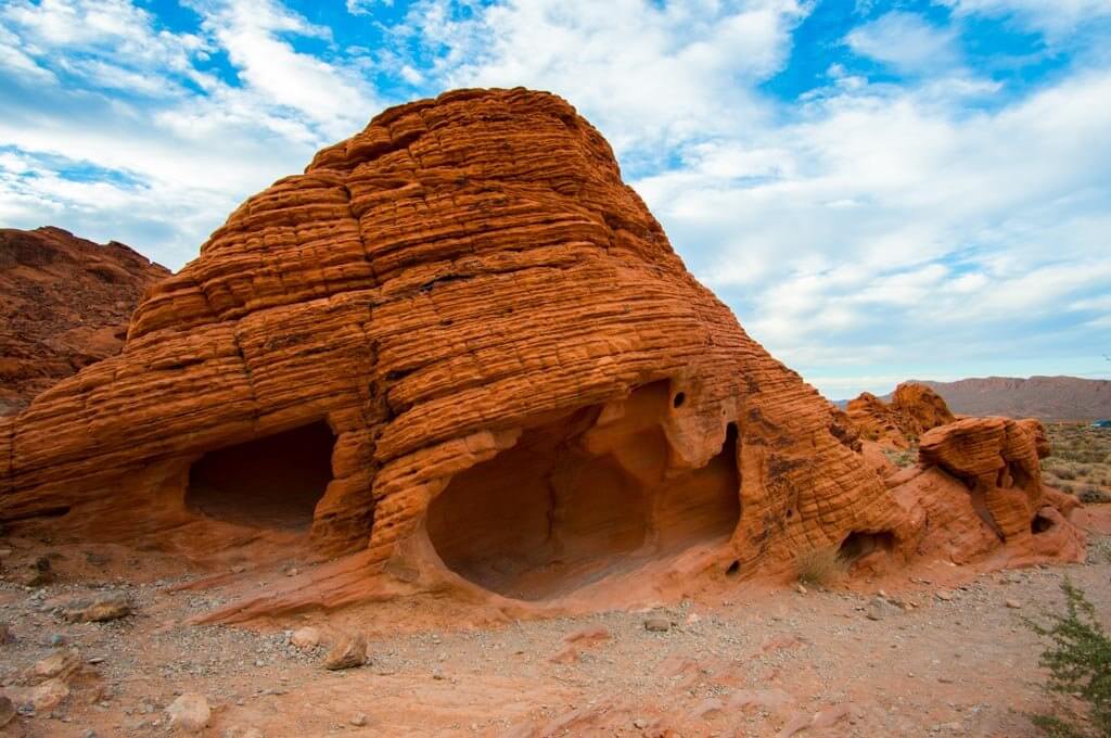
Back on the main road, the closest point of interest to the west entrance are the Beehives! You’ll know them when you see them! They’re large cone shaped rock formations with twists and waves in them resembling a beehive. They’re also fun to climb around in and get some cool photos at!
Mouse’s Tank Road
Halfway down Valley of Fire road you’ll come to another road going north that leads to the visitor’s center and other stops. This is Mouse’s Tank Road, also known as White Dome Road.
Visitor’s Center

Halfway down Valley of Fire road you’ll come to another road going north that leads to the visitor’s center and other stops. Definitely stop here to get more information on the area, a map if you don’t have one already, and there is a short hike to “Balanced Rock” here too. Also as I mentioned before, you can refill your water bottles up here!
Mouse’s Tank Trail

An easy 3/4 mile round trip walk on a sandy trail, lined with desert vegetation, and surrounded by boulders with wind blown holes in them and petroglyphs throughout! We did this trail in the later afternoon and thoroughly enjoyed it! Mouse’s Tank gets it’s name from a Paiute outlaw, named Little Mouse, that hid out here back in the late 1800’s. At the end of the trail, there’s also an area that is a “tank” for water to pool in when it rains. We didn’t see any water when we were there unfortunately!
Rainbow Vista Trail


We stopped at this viewpoint where there was a parking lot and restrooms and noticed it was the start of a trail. The sign said it was 1.75 miles. We only had so much time so didn’t get to do the trail, but most of the people there were heading up a very large rock right alongside the parking lot. So we followed suit and hiked up it as well! The view was beautiful from up there, and you really do see all colors of the rainbow in the landscape: Red, Orange, Yellows in the rocks; greens in the creosote and other bushes and cacti; blues in the sky; and purples in the distant mountains!
Fire Canyon Road & Silica Dome
Another road will show up on your right as you travel north, called Fire Canyon Road. At the end is “Silica Dome”, a white formation that’s “almost pure silica” as the sign at the viewpoint says. It’s quite remarkable seeing the white against the red sandstone.
Fire Wave
Did you ever hear of “The Wave”, the famous rock formation in Arizona that requires a permit to go in and see? Well Valley of Fire’s “Fire Wave” is a similar site to see. It’s 1.5 miles round trip, and there is no shade on the trail–so it’s best done in the early morning or evening, or in the cooler months. I’ll be honest and say I didn’t get to do this trail, mainly because I didn’t do my research beforehand and honestly didn’t know about it! But it is said to be one of the best trails in the park, so it’s first on my list for my next visit here!
White Domes


At the end of Mouse’s Tank Road you’ll come to a dead end at White Domes. A 1.25 round trip loop trail takes you past beautiful rock formations(kind of redundant for me to say that I know, they’re beautiful throughout the whole park, wherever you look!), the remains of a movie set (a lot of movies were filmed here actually), and even through a small slot canyon. I have to say this trail was very much worth doing, there were so many interesting things to look at and see along the way, it was really fun!

Further Resources
- Hopefully this gives you a good overview of the park! If you’re wanting more information on the geology, wildlife, etc, I recommend Valley of Fire Hiking & Adventure Guide book.
- You’ll need to rent a car to get here if you’ve flown into Las Vegas.
- Don’t want to adventure out on your own? Take a guided hiking tour of the park!
- Also, don’t forget to bring a good shade hat!
Save this article for later on Pinterest!
